Letters
Region
Abstract Paintings & Tribal Masks Exhibition At New Hampshire Antique Co-Op
Now on view through May 31, 2020
Congregational Church Stays Connected
During the suspension of in-person activities in light of the Covid-19 situation, the Congregational Church of Amherst, UCC has a variety of ways for members and others to connect with church programs. This is especially important during April as Holy Week and Easter are on the horizon.
The most up-to-date information about church activities can be found on the church’s website (ccamherst.org) or by calling the church office at 673-3231. Sunday services are broadcast on FacebookLive and recorded for later on-line viewing. Services are followed by a Virtual Fellowship Hour. Links for these and other events can be found on the website.
The church’s Facebook page is another source of information, including updates and video messages from the pastors. Pastors Maureen Frescott and Kate Kennedy are available to provide pastoral care during this time, and the church welcomes community members to connect with this loving, serving, open and affirming community of faith.

Historic Amherst
Earliest Maps of Amherst, N.H.
From Quohquinna__-_ to Narraganset No. 3 to Souhegan West to Amherst
BY KATRINA HOLMAN
Digital versions of three early maps of Amherst, New Hampshire, namely the 1806 hand-drawn map and both 1858 maps, Village and Town, have recently been added to the Town’s website under Heritage Commission (which is under Boards & Committees), making these maps easy to access and much easier to study. Maps are valuable resources for gaining a better understanding of the history of a place. Both were part of statewide mapping projects, making it possible to compare Amherst to other towns on those dates.
Here is an overview of early maps of Amherst:
1660 plats of 3 land grants at place called Quohquinnapasskessanahnoy by the Indians, along both sides of Sowheaganuck [Souhegan] River, “in the wilderness” of the Massachusetts Bay Colony, west of Merrimack River:
1) Eastern “farm” – 700a granted to John Wilson Senior of Boston, of which 400a are on north side of river which included land of present 2 through 30 Thornton Ferry Road 2 and 369, 377 & 382 Boston Post Road lots. (Once he finally had tangible land, Rev. Wilson (1588-1667) quickly sold the property to Simon Lynde (1624-1687) of Boston, in whose family it passed down through descendants. It is labeled “Goudges farm” on one S.W. Proprietors’ map and “Col. Gouge” on another version, for Col. Joseph Gooch Sr. (1700-1770), a lawyer, who in 1724 had married Lynde’s great-granddaughter Elizabeth Valentine.)
2) Middle “farm” – 500a granted to Capt. Wm Davis of Boston & Capt. Isaac Johnson of Roxbury, of which 230a are on north side of river, roughly centered on the confluence of “a beaver brook.” (Another plan of 500-acre “Capt. Davis farm” survives as a 1732 copy of 1727 plan, which indicates that the bounds had been renewed in 1681 by three men named Davis, likely the original William’s heirs and/or sons, and again in 1738, likely by new owner who may have become its first settler.)
3) Western “farm” – 500a granted to Mrs. Anna Lane, of which 200a are on north side of river.
The acres on north bank would become part of Narraganset No. 3 “plantation” aka Souhegan West township in 1728 and those on south bank part of Dunstable then Monson until 1770; all are now part of Amherst. (Laid out by one Jonathan Danforth, surveyor, who was of Billerica according to Gilman’s History of Nashua, which was the same hometown as our first settler Sam Lamson. Court records transcribed and drawings depicted in New Hampshire Provincial & State Papers vol. 24, 1894, p. 9-11. The 1727/ 1732/ 1738 plan of 500-acre “Capt. Davis farm” is contained in Howard Locke house notebooks, sorted under Town #33, the former Poor Farm, housed in Amherst Town Library; a photocopy with transcription appears in Newsletter of Amherst Historical Society, June 2010, in article by Bill Wichman.)
1728 surveyor’s plan of Narraganset No. 3: “Containing 23,040 acres or the contents of six miles square exclusive of the Pond [Baboosic] & part of three Farms that were formerly laid out [in 1660, land north of Souhegan River of Wilson; Mrs. Lane; and Davis & Johnson.].” As the objective was to establish the perimeter to be approved by the Massachusetts General Court, the only landmarks shown are those on or near the perimeter: Souhegan River (“drawn partly by guess”) forming the south boundary; the end of a brook entering the river at the SE corner; and a “Large Pond” (depicted in relative size but without attempt at accurate contour) near the eastern boundary about halfway up with a brook that extends eastward across the border. (Laid out by one John Chandler Jr., surveyor, assisted by another surveyor and two chainsmen on behalf of Proprietors, who were subgroup of Narraganset War soldiers or their heirs. Reproduced in N. H. Provincial & State Papers vol. 24, 1894, between pages 8 & 9, taken from Massachusetts Maps & Plans Vol. 6, p. 31.)
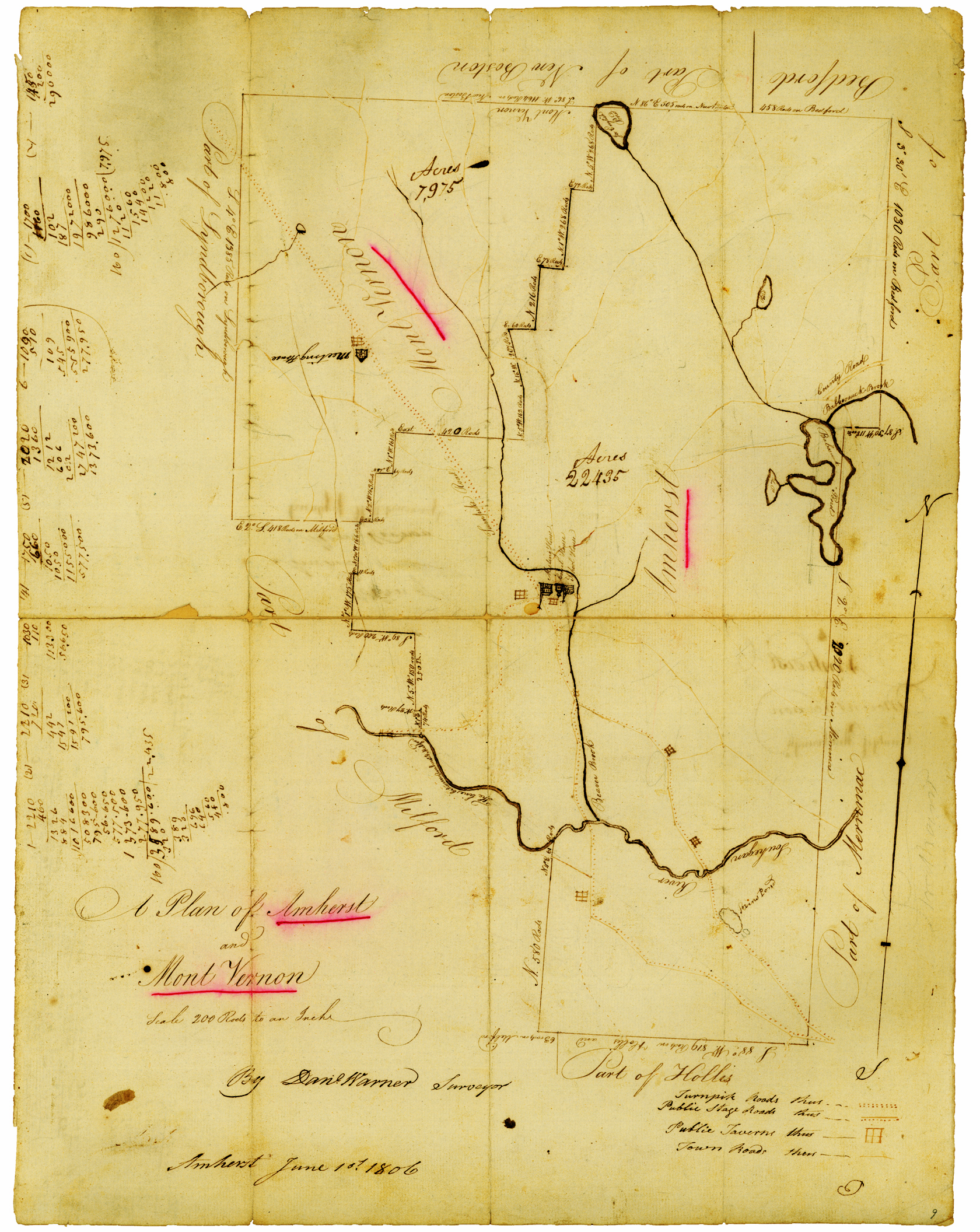
1806 map of Amherst, N.H.
Circa 1740s Proprietors’ maps of Souhegan West (at least 3 versions): Show lot divisions, with each lot numbered, of same territory laid out in 1728. One of the original Proprietors’ maps, which includes Third Division lots outlined in red, is dated Dec. 1748. However, these maps were probably created over the course of about two decades, given that the first lot division was made in 1734 but an annotation labeling Lot 46, which lies east of Baboosic Lake, with the name HOGG must have been added after June 1757 (deed Lovejoy to Hogg). The Chapel copy does not have the HOGG annotation but does show the 1750 townline change giving a sliver off the eastern boundary to the Town of Merrimack so that the townline bisects Baboosic Lake and some original S. W. lots. The alignment varies between the different versions; for example, at what position the brook flows through Lot 50. (Three vellum versions hang in Amherst Town Hall upstairs; a more-legible copy is housed in Chapel Museum.)
1806 map of Amherst (22,435 acres) & Mont Vernon (7,975 acres): First map of Amherst, N.H. with essentially the same boundaries as today. A unique aspect of this map is that it shows public taverns: two in the Village (which research identifies as 1 Carriage Road and Samuel Curtis’s hotel on south side of Common); and three more in the southern part of town (John Eaton’s at 344 Boston Post Road; Timothy Kendall’s better known as Fletcher’s after later proprietor at 382 BPR; and formerly Danforth’s at 107 Ponemah Road). The center is indirectly identified by Meeting House, Court House, and School House. Symbols distinguish three kinds of roads: turnpike, “public stage roads” and “town roads” but the road crossing townline to Bedford (roughly where present Route 101 crosses) is labeled “County Road.” There is only one Turnpike (in NW corner of town, terminating in Village); and there are only three stagecoach roads in Amherst, all leading southerly from the Village: one heads west out Main street to Milford Village; the other two head toward Boston, joining, splitting and joining again – the east-most being Courthouse Road and the middle one being Boston Post Road, which join up for a stretch before splitting into Boston Post Road (the southeastern branch) and Route 122, which heads southerly toward Hollis but after crossing the river veers easterly (along what is now called Old Nashua Road) to join up again with the other branch just beyond the SE corner of Amherst, probably present junction of Boston Post Road and Craftsman Lane in South Merrimack. Also shows and names bodies of water – river, brooks, ponds. (Original, hand-drawn by Daniel Warner of Amherst, surveyor, housed at N.H. State Archives in Concord, called Carrigain manuscript because done for his state-wide mapping project.)
1858 maps of Amherst, Town and Village: Depict and label buildings – identifying dwelling houses by owner’s name and commercial and public buildings by function. Abbreviations include: S.M. for saw mill (4 of them besides one in Village); B.S. for blacksmith shop (3 in Village, 1 in south part of town); W.W.S. for wheelwright shop (1 in Village, 1 in south part); S.H. for schoolhouse (9). Also show roads. Town map shows railroad line; and depicts and names bodies of water. Remarkably accurate, but contain just a few errors where changes were made between 1857 drawing and 1858 publication (for example, Vestry in Village, now Chapel
museum, on wrong side of road because built after map drawn in newly chosen location; label for new owner of 1 Church St., Hartshorn who bought from Mrs. Underhill in 1857, is across street over 3 Manchester Road house; 369 Boston Post Road still has name of S. Carter although his heirs sold house in 1857). These maps note several sites then considered historically significant: birth place of Hon. H. Greeley (114 Horace Greeley Road near Bedford line); birth place of Hon. Chas. G. Atherton (24 Courthouse Rd); and “First House Built in Amherst” over B. Melendy (244 Boston Post Road). 1858 Town map gives similar details for adjoining towns for areas that fit on same page. (Typeset. Facsimile, (re)published 1982 as boxed set of individual sheets, is in collection of Amherst Town Library.)
1881 map of Amherst School Districts: Only map that shows bounds of school districts (12). Shows locations of 9 schoolhouses; roads, railroad, and bodies of water. (“Presented to Selectmen of Amherst by Edward Aiken.” Original colored manuscript in Amherst Town Hall vault; facsimile exhibited in Chapel Museum. Untitled and undated.)
1883 map of Amherst: Indicates changes in town boundaries with dates. Names geographic areas; depicts and names bodies of water, bridges, turnpike, railroad line, railroad station. Identifies schoolhouses, town farm, cemeteries; and indicates locations of dwelling houses (except not individually distinguishable in Village). Shows roads. Two historical sites are noted: “First Meeting-House erected in 1738” north of center and “First Settlement in town, about 1735, by Samuel Lamson” south of center. (Frontispiece in Secomb’s History of Amherst, N.H.)
1892 maps of Amherst, Town and Village: Same type as 1858 but riddled with errors (houses missing, houses on wrong side of street, wrong owner names; even labels wrong house as birthplace of Horace Greeley) – so use with caution! Indicates P.O. at RR station and includes standard information such as railroad line, and location of schoolhouses. Does not show any details for surrounding towns. (Amherst Town Library has copy.)
1906 topographical map of Milford Quadrangle, including all of Amherst: Names bodies of water and hills (except Patch Hill off Lyndeborough Road is not named). Danforth’s Corner area in SW part of town has been renamed Ponemah. Also shows roads and houses (as small black squares) and public buildings including town hall, schools, churches (as + over square, no names) but P.O. is not indicated. Cemeteries have their own symbol. Shows and names two railroad lines but not stations. (Surveyed 1904; engraved 1905; published 1906. Viewable and downloadable from USGS Historical Topographic Map Explorer at livingatlas.arcgis.com/topoexplorer/index.html .)
1941 map of Amherst Village by Seaman & Boardman: Actual shapes of buildings, including barns; dwelling houses labeled with personal name that is first initial and surname; public and commercial buildings labeled with names. Some old buildings that no longer existed are shown with X on them (such as Old Jail, Horse Sheds, house & store at NE corner Church St & Old Jailhouse Rd). Streets have names (some different from today). The Common is labeled PARK. (At bottom right corner is F. W. Seaman’s monogram with date 1941. At bottom left is hand-printed: “MADE UP BY T. E. BOARDMAN (1942)”. In Chapel Museum.)
1942 map of Amherst, both town and detail of Village on same sheet, by F. W. Seaman: Houses (most indicated with same square symbol) are labeled with owner’s surname. Errata: in the Village, Hotel Carriage House is missing. Most roads are named; shows only one rail line but not the station. Hills are indicated with their elevation feet. Beaver Brook is called Quoquina__. (Original hand-drawn and hand-lettered. Version in Chapel Museum annotated: “DONATED BY T.E. BOARDMAN (ENLARGED FOR ME BY MY UNCLE).”)
There are more maps, of course, but this seems a good place to stop for a list of “early” maps.
Katrina Holman welcomes comments to HistoricAmherstNH@juno.com